Caves: Karla Caves
These are among the oldest caves in India and date back all the way to 160 BC. The principal cave is the largest Chaitya among Buddhist cave in the country, 15 meters wide and 16 meters high. The most remarkable feature of the cave is its arched roof supported by wooden beams which have astonishingly survived the onslaught of elements for more than 2,000 years. The Wooden Umbrella above the Chaitya is unique in the Buddhist caves around the world. There is absolutely no sign of any corrosion.
To get to Karla you have to take a 12km drive along the highway towards Pune and turn left a little after passing MTDC Karla Caves Resort and then drive further 3km down a narrow road. Regular S.T bus services are available from Lonavala. From the base it is a stiff 600 feet climb to the top and it is recommended that adequate water is carried along by you.
At the entrance of the principal cave is the
Religion and art are so closely inter-linked in
Then with the hammer and chisel, pillars and intricate sculptures were carved by one set of people all at one time. Such was the artistic excellence of the artisans and the genius of the designers, as the architecture is geometrically perfect and the engineering designs flawless. There are about 1000 rock cut caves in Western India, a large number of which are about Lonavala whose original name, Lenauli, means the places of many caves (lena meaning cave). Of these the most famous are at Karla, Bhaja, Bedsa and Kondane.
The concept of retreating to solitary caves in forests or mountains for meditation was common to Hinduism, Buddhism and Jainism so that, where no natural caves existed, it was but one more step to carve out a cave. However, in a view of the importance of monasticism in Buddhism, the largest number of caves is Buddhist in origin. Amongst these caves were the Chaitya (Chapel or Cathedral) for the holding of prayers and rituals and the Vihara (monastery) for the residence of Buddhist monks. There were two periods of high creative activity in the building of rock- cut temples in this area, the first from the 02nd century BC to the 02nd century AD and the second from the 05th to the 10th centuries AD. In the early period Hinayana Buddhism (or the Little Vehicle) prevailed and in the latter, Mahayana Buddhism (or the Great Vehicle). In the Hinayana period, to which Karla belongs, the architectural design was wood based, being copies of wooden buildings of an earlier age. Also, as the Buddha, not wanting to be defied, had decreed that after his death, "neither the gods nor men shall see him", in this period he is represented by symbols. The lotus or elephant , symbolizing his birth, the Bodhi tree under which he attained Nirvana ( enlightenment) , the wheel of law which he set in motion, a Stupa or mound symbolizing his death, a throne symbolizing that he is a prince among men, his footsteps which the Buddha is represented in sculptures and paintings of the early phase.
Distance from Lonavala Station: 12km.
Transportation mode: S.T. Bus or one can hire bicycle or private taxi up to the Karla caves.
Places to Stay: Best place to Stay is MTDC Karla Caves Resort, around 4 kms from the caves. One can make advance booking in Pune and Mumbai as during weekends it is filled up. The resort also has Water Sports facilities. Other options is to stay in Lonavala which is around 1-15 kms from the caves.
Easy Trek: Lohgad Fort
Lohgad is one of the two forts which guarded the earlier trade route between Kalyan and Nalasopara harbors & markets of Deccan plateau (other fort being Rajmachi). Today, most of the forts are in dilapidated state; however Lohgad is still in much better condition. For trekker's Lohgad should be a real treat to visit giving a wonderful panoramic view from its top.
Lohgad is situated about 5 Km. from Malavali station. From Mumbai, first one should reach Lonavala by any Central-Southern Mail/Express, catch a local train from Lonavala to Malavali. From Pune, people can catch any local to Lonavala and get down at Malvali. From Malavali one can catch a rickshaw to Bhaje village. 1½ hours walk from Bhaje will lead to Lohgadwadi. Around 15 min walk from Lohgadwadi will take you to the top.
From a trek point of view, Lohgad is just a hike. People are even able to drive up to Lohgadwadi. But even then Lohgad has a charm of its own.
Being a well preserved fort the entrance to the fort is in good condition. The fortifications are also quite good. There are some stone-scripts (Shilalekh) in the den, the only place where night stay can be made on Lohgad. There is a mosque atop Lohgad. From Lohgad, Tung and Tikona hills are seen to the South; Dukes nose to the West, Pavana dam offers a wonderful view in the South direction. Lohgad trek could be supplemented by Visapur trek, Bhaje caves & Karla caves in two days programme. The schedule for completing this trek is as follows:
- Reach Lonavala by Indrayani or Deccan Express in the morning.
- Come to Malavali by local train. Catch a rickshaw for Bhaje village. Reach Bhaje caves within 15 minutes. Have a lunch there and leave for Lohgad.
- Reach atop Lohgad by 4:00-4:30 p.m. Have a look around the fort, stay in the den (on the right side(valley side) just after Ganesh Darwaja.)
- Leave Lohgad early in the morning (at about 7:00 a.m.) come down and go to Visapur. Reach Visapur by 10:00-10:30a.m. Take a look around and have your lunch at Visapur.
- Leave Visapur and come to Bhaje by 1:00-1:30 p.m. catch a rickshaw and go to Karla caves (opposite of railway station). Have a look around the caves for an hour.
- Come down and catch a bus or six seater to Lonavala. Get into Deccan Express (4:25 p.m.), Udyan Express (5:10p.m.) or Koyna Express (5:20 p.m.) and reach Mumbai.
The aerial view of Lohgad resembles that of a Scorpion, and the traverse on the scorpion tail is a treat during the monsoons. It becomes quite slippery in that section and one has to be watchful while climbing down on a small patch while trying to reach the tip.
Click Here to see the GPS map of Lohgad, Visapur and Bhaje Caves.
Also see another map detailing about the tourist spots in the lonavala region.
Click Here to see the photos of Lohgad Fort during monsoons.
Map: Location of beaches in Ratnagiri District (Konkan Region)
A detailed map of the location of the major beaches in Ratnagiri district. The map gives the road connectivity between major tourist spots - beaches, forts, fishing villages, temples etc.
One can find the location of major beaches like- Guhagar, Ganpatiphule, Harnai relative to the Mumbai - Goa highway passing parallel to the coastline. The must visit places also include Anjanvel (a fishing village, with Gopalgarh fort and a lighthouse overlooking a cliff), Dhabol (famous for the ENRON debacle), Hedvi and Velneshwar for serene surroundings and Temples.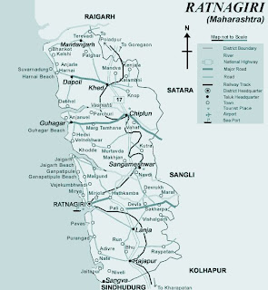
More Information for each of these places will follow.
Driving Directions: Kashid
For Mumbaikars, the route to Kashid is an extension of the drive from Alibaug. Many might have crossed Kashid on way to Murud-Janjira from Alibaug. Take the Panvel-Penn route to Vadkal Naka, bypass Alibag town and head straight towards Revadanda Bridge. At the Revadanda Police post, meet the SH60 from Pune. However the crowd traveling to Murud-Janjira directly from Mumbai might have missed Kashid if taken the alternate route on Goa Highway via Kolad, Roha and a left diversion just beyond Roha town through SH92.
Punekars, greedy to utilize the Express Highway to the maximum, generally take a longish route via Khopoli – Penn – Vadkal Naka. Not only the route turns out to be longer, what you miss is the beauty of Mulshi-Tamhini. True, the state highway does not offer the luxury of cruising speeds as the Express Highway, but the savings in time is more than offset by the longer route. After crossing the Tamhini Ghat on SH60 always keep an eye on the Kolad milestone and head towards the Goa Highway. Be careful not to take the Mangaon detour near Vile. Once you reach the
Milestones from Pune (Kothrud, Paud Road):
Paud (25) – Junction near Vile (87) – Goa Highway, NH17 (108) – Left turn at Kolad (109) – Roha (122) – Vikram Ispat, Salav (156) – Police Post, Revadanda (157) – Kashid (170)
Click here for detailed travelogue to Kashid.
Travelogue: Kashid - The Hammocks Beach
The journey to Kashid from Pune starts and ends on SH60. The 4 hour long drive on this 170 Km stretch is all about nature; her color, variety, landscape and fauna. As you hit Paud Road in the city, take the turn at Chandani Chowk towards Mulshi, cross the ghats of Pirangut and speed aside the lake, the color of spring welcomes you at the Tamhini ghats. Mulshi has always been a monsoon-delight; the raging falls enticing you to drench in gay abandon as the deep blue waters of the lake lay calmly in the picturesque backdrop. While Mulshi lets you touch and feel her wildness, Tamhini this spring unfolded as an ethereal beauty that stays at a distance. Driving down that stretch till we hit the Goa highway was therefore a fascinating journey of feasting the eyes that’s best reproduced when clicked. Nudity of nature has never been so pristine, we felt, as the mountains tried to guard her privacy.
Taking a detour at Kolad from a small stretch on the
What happens beyond Revadanda is a thrilling experience of driving along the perimeter of India! The seas kiss the highway now and then, withdrawing at times, only to come back with all wildness that the shoreline can only resist. Urban vegetation has long been left behind, what passes us now are small coastal villages after every milestone. Chener, Mithekhar, Ambali, Yesde, Shirgaon, Walke, Satirde are but poor glimpses of what lay in the shores beyond the hills ahead, populated by mankind not more than a thousand. The afternoon sun reclined towards the sea, as the skyline in the horizon turned shimmering emerald before we lost the sea view at the impending turn into those hills.
Downwards from the hills, out of nowhere, what appeared to our right, below, was a long arching shoreline bathing in raw sunshine. A façade of blue and white, nestled by hills on her two sides and a long row of Casuarinas, shading the third. Joy at first sight . That is Kashid !
Far from the madding crowds that throng Alibaug-Murud-Janjira in the vicinity, Kashid is a sleepy village that has its own niche tourists. As you hit the sea level from the hills again, dense foliage pervades the highway on both sides. The sea and the sand appear across the long stripes of the trees, secluded and un-spoilt. Park your car in the shades and sway in the cool breeze from the hills. Sultriness is gone…. you do not sweat…..and amazingly the sea breeze does not bring in any humidity.
It is criminal not to savor every moment in Kashid. Forget sightseeing, there’s nothing to see except seas and the sky. Forget shopping, there no shop except those small village joints. Forget water sports, you do not even see a fisherman’s boat. Kashid is all about virginity epitomized. Laze around in the sun, drench under the deep blue sky and doze off in those innumerable hammocks. That’s Kashid for you.
Kashid is all about hammocks. Gearing up to rush into the seas? Collect your energy on the hammocks. Tired after that wild jig? Catch your breath in the hammocks. Not in a mood to get wet? Watch from the hammocks. Is the poet in you coming out? Pen those lines in the swings of the hammock. No wonder then, in any dwelling you land up in Kashid, hammock is an amenity more than an AC. With 6 hour power cuts during summer and the cool breeze of the coconut grove, who wants an AC anyways?
Kashid is all about silken sands. Pristine white, loose and clean; A stark contrast in the Konkan coast where the shorelines a typically dark and sticky. Kashid is an exception. Run like a sprinter, they don’t drag you; roll like a kid, they don’t itch you; sleep like a log, they don’t burn you. One wonders, why Rakesh Roshan went all the way to NZ for shoot.
Kashid is all about the Rawas fries by Mrs. Khopkar. Barge in to the cool garden house, check in to the brand new room upstairs, flip open the kingfisher cans….and have a Rawas fry. Drop dead on the beach; trudge back to the car; collapse on the hammock - with a Rawas fry. Order a veg. meal, finish off the roti-sabji, gulp down the dal… top up a Rawas fry. Go dipsy in the evening… over a Rawas fry. Wind up dinner… after the last Rawas fry. Kashid is full of such warm, homely people, spreading out comforts of stay and food in a home away from home. Tired of Rawas fries? Have Rawas fry, for a change.
….and Kashid is all about the moonlight at dawn. Its 6 o’clock in the morning. Pitch dark under the shades. The sea froth vigorously hitting the shores. The hills on the far side projecting into the sea as a dolphin’s nose; and the skyline is not yet crimson to make you see all these. It’s a full moon dawn on Kashid beach! A morning shoreline basking in midnight glory; Who ever said cuckoo heralds the dawn? In Kashid, it’s the moon.
Driving back home that afternoon, upwards into the hills, as we took that impending last turn, what appeared to our left, below, was a long arching shoreline bathing in raw sunshine. A façade of blue and white, nestled by hills on her two sides and a long row of Casuarinas, shading the third. Sorrow at last sight - That is Kashid!
Blowing a flying kiss behind, we lost her across the sylvan slope of the hills.
Last 4 times I have stayed with locals and for people who like adventure this is a good option. I would recommend Sagar Toursit Resort as a very good option. This is managed by Deepak Khopkar and his wife both of whom are friendly. The arrangement is that they give you the complete house - one hall and 2 small bedrooms and a toilet and bath. This place is less than 1/2 km from the beach around 200 meters from Suman resorts. The house is in a plot which is full of coconut and areca nut plants and is really homely. The food served by Mrs. Khopkar is traditional but nonetheless very tasty. Also it should be noted that the Khopkars have a separate house in the village where they stay and sot you have complete privacy.
Another similar place is Sea Touch Cottage. Sarve Huts is also highly recommended from my friends – though it is slightly on the costlier side. The tariff when I last visited was Rs. 800 per head for stay and food. The food served here is also Awesome.
Contact Information:
Sagar Tourist Resort: Deepak Khopkar 9422692463, (2144) 278525 (Resort)
Sarve Huts: Mr. A. G. Sawant 9820548997, 952144278539 (Resort), 56243067 (Booking Pune)
Sea Touch Tourist Cottages: Tulasidas Belose (2144) 278550, (2144) 278588
If someone finds updated contact information please put in the comments so that it can be updated.
Click here to get the detailed route information from Mumbai and Pune.
Photos: Lohgad Fort
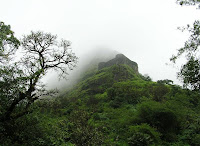
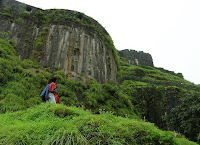
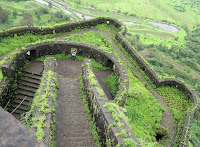
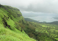
These photos of Lohgad are from the climb from Pawna Lake side. The lush green beauty of the fort in the monsoons is enticing. Though for trekkers this fort is a cake walk, but the sheer beauty of the place covers up for everything. The fort still has major fortifications intact and with all the green surroundings make an amazing view.
The entrance section of the fort facing the Pawna lake is a must visit spot - it should be named the 'Wind Gates'. Sitting on the ledge here is an experience in itself - But do try it on your own risk as the wind speeds here can blow you away - LITERALLY.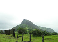

Map: Location of forts in Lonavala Region
Map detailing the location of various forts and lakes in the Lonavala region. One can see the geographical location of famous trekking routes in this region in reference to the railway line. The map gives details about the position of - Sudhagad, Telbaila, Korigad, Tung, Tikona, Visapur, Lohgad, Rajmachi, Dhak and Peth Forts.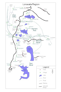
The map is from old archives, so am not able to acknowledge where I have picked it up. Please comment if someone knows about it, I will be happy to acknowledge the site.